
The Florida Peninsula at Night from Space


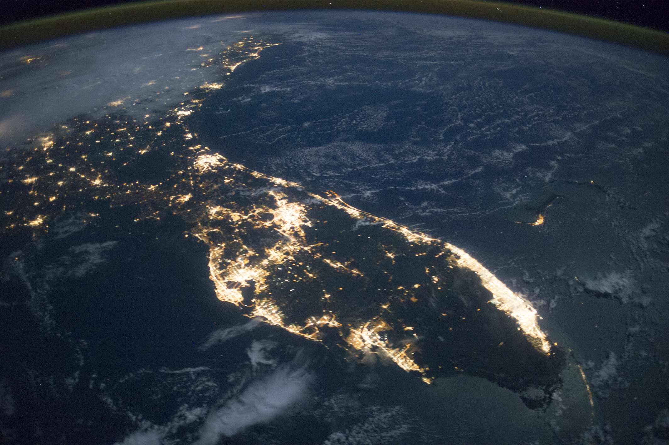
Astronauts aboard the International Space Station took this photograph of Florida in October 2014. The peninsula is highly recognizable even at night, especially when looking roughly north, as our map-trained brains expect.


Astronaut photograph ISS041-E-74232 was acquired on October 13, 2014, with a Nikon D3S digital camera using a 24 millimeter lens, and is provided by the ISS Crew Earth Observations Facility and the Earth Science and Remote Sensing Unit, Johnson Space Center. The image was taken by the Expedition 41 crew. It has been cropped and enhanced to improve contrast, and lens artifacts have been removed. The International Space Station Program supports the laboratory as part of the ISS National Lab to help astronauts take pictures of Earth that will be of the greatest value to scientists and the public, and to make those images freely available on the Internet. Additional images taken by astronauts and cosmonauts can be viewed at the NASA/JSC Gateway to Astronaut Photography of Earth. Caption by M. Justin Wilkinson, Jacobs at NASA-JSC.


Florida at Night


acquired October 13, 2014 download large image (2 MB, JPEG, 2128x1416)


Illuminated areas give a strong sense of the size of cities. The brightest continuous patch of lights is the Miami-Fort Lauderdale metropolitan area, the largest urban area in the southeastern U.S. and home to 5.6 million people. The next largest area is the Tampa Bay region (2.8 million people) on the Gulf Coast of the peninsula. Orlando, located in the middle, has a somewhat smaller footprint (2.3 million). A nearly straight line of cities runs nearly 560 kilometers (350 miles) along the Atlantic coast from Jacksonville, Florida, to Wilmington, North Carolina.

South of Orlando, the center and southern portions of the peninsula are as dark as the Atlantic Ocean, vividly illustrating the almost population-free Everglades wetland. The lights of Cocoa Beach trace the curved lines of Cape Canaveral and the Kennedy Space Center, an area well known to astronauts. Dim lights of the Florida Keys extend the arc of the Atlantic coast to the corner of the image. The small cluster of lights far offshore is Freeport on Grand Bahama Island (image right). The faint blue areas throughout the image are clouds lit by moonlight.
Instrument(s): 
ISS - Digital Camera
NASA Earth Observatory

Comments

Popular posts from this blog

My Little Africa - Kestel Lion Park - Free State - South Africa

Our staff visit My Little Africa - Kestel Lion Park - Free State - South Africa... Located off the main N5 Highway between Harrismith and Bethlehem... Nestled within the small cosy town of Kestel... My Little Africa Map Address : Jan Van Riebeeck St, Kestell, 9860 Hours :  Closes soon: 5:30PM ⋅ Opens 9AM Sat Phone : +27733 731 3034 This lion park is lovely... We were able to Interact and Play with the Lions and Snakes... A thrilling experience that built Trust, Confidence, Team Work, Courage and Personal Development ... My Little Africa has a variety of animals such as Lynx, Wildcat, Snakes and Lions... The park relies on visitors and donations and is ideal for a school excursions that wont break your budget... My little Africa has been in operation for a good number of years... For Guided Safe and PRIVATE South African Rural and Animal Tours email geosollab@gmail.com... More Drakensberg Videos...  Dr...

Tugela Ferry - Msinga - Muden Adventure - Rural Skills Development - Job Creation

The Kwazulu-Natal Department of Public Works has undertaken a school sanitation project to construct new toilet blocks for male and female, grade R learners and teachers in the Umzinyathi District   M unicipality located within the Kwazulu-Natal province. Various schools were identified within the Muden, Tugela Ferry and Msinga areas for geotechnical investigation studies. The Ramgoolam Group   together with Naidu Consulting Engineers   have requested Geotechnical Solutions (Pty) Ltd   to carry out geotechnical investigation studies for selected schools. Here is our Adventure... Tugela Ferry is a town on the northern bank of the Tugela River, in central KwaZulu-Natal, South Africa. During the apartheid era it formed part of the KwaZulu homeland, and at present it is included in the Umzinyathi District Municipality.... Schools included: GeoSolutions List of Learner Schools Emachunwini - Holwane - Mzomusha - Ntshishili - Sibumba - Nomaqulu - B...

One Home - One Garden

The One Home, One Garden initiative has been undertaken to empower deep rural area populations. The  South African Department of Health  runs and encourages the initiative. The Department provides essential medical services to poor deep rural communities located all over South Africa. Deep Rural - Mkhwamunye and Nhkezuka looking towards Mazabeko Most clinics have beautiful gardens cultivating fresh produce ... Nondweni Clinic (below)... These Gardens enable local skills development and provide various income opportunities to the local community folk. Geotechnical Solutions  together with the  The Rangoolam Group  has undertaken various challenges enabling the construction of essential sanitation and water services to these remote areas and clinics. Clinics outlined included Rorkes Drift Clinic - Hlathi Dam Clinic - Nondweni Clinic - Mazabeko Clinic - Collessie Clinic - Mandleni Clinic - Eshane Clinic - - Douglas Clinic - Ethembeni ...